#201 - 5760 Teredo St
Sechelt, BC V0N 3A0
Canada
Sechelt, BC V0N 3A0
Canada
|
#201 - 5760 Teredo St
Sechelt, BC V0N 3A0 Canada |
|
|
La Pérouse: 1786 Chart of the B.C. Coast
SECHELT, BC — APRIL 14, 2008 — Local real estate agent Gary Little has written the following article as a memorial to the 220th anniversary of the death of French explorer Jean-François de Galaup, Comte de La Pérouse who surveyed the coast of British Columbia in 1786 as part of a scientific exploration of the Pacific Ocean. The article describes in detail a chart of the B.C. coast which was first published in 1797 in the atlas to his book Voyage de La Pérouse Autour du Monde. This is one in a planned series of articles on the history of B.C. to celebrate the sesquicentennial of the founding of the Crown Colony of British Columbia in 1858.
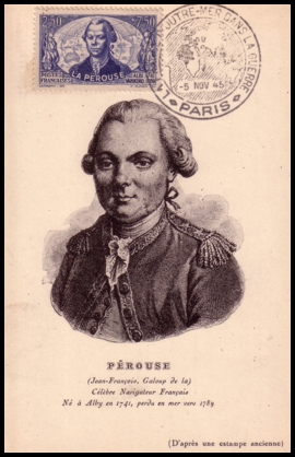
France issued a stamp in 1945 to honour La Pérouse His next visit to Canada came in August 1782 when he led three navy ships in a surprise raid of the two Hudson's Bay Company trading posts on the west coast of the Bay — Prince of Wales Fort and York Factory. Both posts were sorely understaffed and surrendered quickly in hopeless circumstances. La Pérouse seized all the fur pelts he could find, then had the forts razed, though he did allow the captured traders to sail back to England unharmed. (This included Samuel Hearne, the governor of Prince of Wales Fort, famous for his 1771 trip to the mouth of the Coppermine River which established there was no northwest passage south of the Arctic Ocean. La Pérouse allowed Hearne to keep his journal of this important expedition and recommended he publish it as quickly as possible. As it turned out, it was not published until 1795, three years after Hearne's death.)
La Pérouse's next — and last — trip to Canada had far more peaceful goals. In 1785-1788 he led a great scientific exploration of the Pacific Ocean for France. His two ships sailed from Brest on August 1, 1785 and one year later, in August 1786, they had reached the coast of what is now British Columbia. His survey of the B.C. coast that month provided the raw data used to create the chart described in this article.
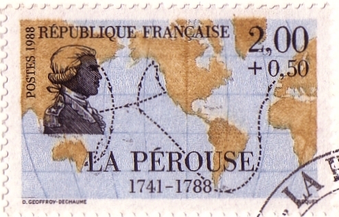
This 1988 French stamp shows La Pérouse's route through the Pacific The title of La Pérouse's British Columbia chart is:
When the atlas of the voyage was first published in 1797 (as a companion volume to his book Voyage de La Pérouse Autour du Monde), it was the only one covering the mysterious northwest coast of America from California to Alaska based on a survey other than Capt. James Cook's well-known survey of 1778. Cook's atlas was published in 1784. Although there were three Spanish expeditions which closely examined the northwest coast in the 1770s, the results were closely guarded as state secrets and not published officially until 1802.
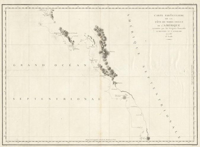
La Pérouse's 1786 Chart Showing the British Columbia Coast The B.C. chart shows the Pacific coast from Tillamook Head in the south (Cap Rond at latitude 45°40′) to the northwestern tip of the Queen Charlotte Islands (now called Haida Gwaii) in the north (Baie de Clonard at latitude 54°10′). This example of the chart is from the second French-language edition of 1799 (published in London by G.G. & J. Robinson). Several landmarks around the Queen Charlotte Islands and Vancouver Island are identified, notably Nootka where Cook had gone ashore in 1778. Vancouver Island is not shown as an island because its insularity was not established until 1792. Like Cook, La Pérouse missed Juan de Fuca Strait separating Vancouver Island from Washington State (at latitude 48°30′); this strait was finally discovered by Capt. Charles Barkley in 1787.
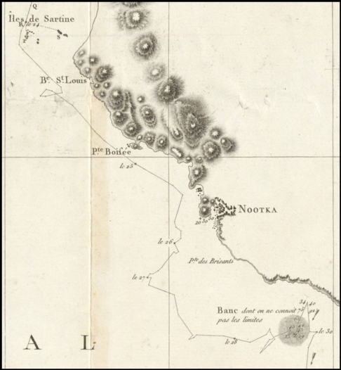
Vancouver Island detail
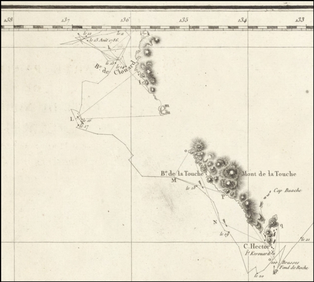
Queen Charlotte Islands (Haida Gwaii) detail Only a few of the place names marked on La Pérouse's British Columbia chart are in use today, most prominently Nootka. Here is a summary of the names used by La Pérouse followed by those found on modern maps:
Pointe Boisée and Pointe des Brisants are translations of the English names Cook had given in 1778 to two prominent landmarks on the west coast of Vancouver Island: Woody Point and Breakers Point. Similarly, Île des Douleurs and Anse des Martirs are translations of Spanish names given by Bruno de Hezeta in 1775 to Washington State coast locations: Isla de Dolores (Island of Sorrows) and Punta de los Mártires (Martyrs Point). La Pérouse's survey of the coast of British Columbia, though sketchy and obviously incomplete, was still more detailed than Cook's. Because of very bad weather, Cook, after leaving Nootka (at latitude 49°34′), had sailed north far offshore until he reached the Alaskan coast (near Sitka at latitude 57°), so his chart shows the unseen B.C. coast as a straight line. Nevertheless, La Pérouse's chart was largely ignored because it was not published until eleven years later in 1797. By this time, more detailed charts of the Queen Charlotte Islands and the west coast of Vancouver Island had appeared. In 1798 the chart was rendered completely obsolete when George Vancouver's superb chart, based on his meticulous survey of 1792-1794, was published. La Pérouse and his crew never returned home to France. Their two ships, Boussole (the French word for compass) and Astrolabe, were wrecked in the Solomon Islands in early 1788 and all hands were lost either to the sea or to murderous natives. Information collected by the expedition survived because La Pérouse periodically forwarded his records to Paris from earlier ports of call — Macao, Kamchatka, and Botany Bay. An original exemplar of La Pérouse's 1786 chart is on display in Gary Little's office at the Royal LePage office in downtown Sechelt, British Columbia.
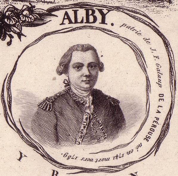
Vignette of La Pérouse found on an 1851 map of the Tarn region of France. La Pérouse was born in Albi, the capital of this region. — * —
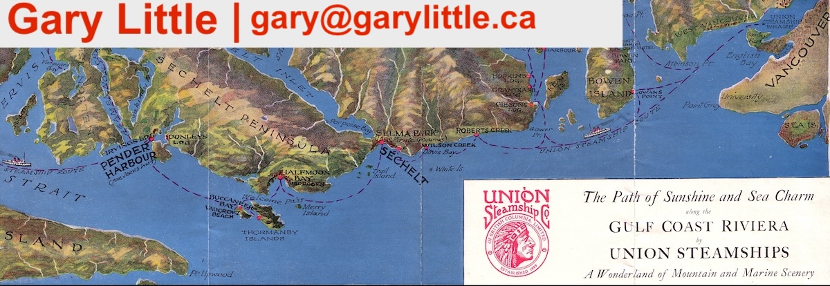
Gary Little is a realtor® and licensed real estate trading services representative in the offices of Royal LePage Sussex in Sechelt, British Columbia, Canada. He is a former senior software marketing manager, having previously worked in Silicon Valley for almost 20 years at the worldwide headquarters of Apple Inc. and Sun Microsystems, Inc. He is well known for his interactive real estate map of the Sunshine Coast (map.garylittle.ca).
— 30 —
CONTACT INFORMATION
Gary Little, realtor® This news release is located online at: http://www.GaryLittle.ca/maps-historic/perouse.html |